


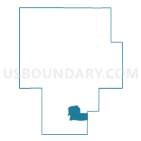
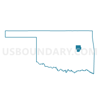
Voting District 13, Okmulgee County, Oklahoma
About
Outline

Summary
| Unique Area Identifier | 654867 |
| Name | Voting District 13 |
| County | Okmulgee County |
| State | Oklahoma |
| Area (square miles) | 13.21 |
| Land Area (square miles) | 13.13 |
| Water Area (square miles) | 0.08 |
| % of Land Area | 99.40 |
| % of Water Area | 0.60 |
| Latitude of the Internal Point | 35.45267860 |
| Longtitude of the Internal Point | -95.92009670 |
Maps

Graphs
Select a template below for downloading or customizing gragh for Voting District 13, Okmulgee County, Oklahoma


Neighbors
Neighoring Voting District (by Name) Neighboring Voting District on the Map
- Voting District 14, Okmulgee County, OK
- Voting District 17, Okmulgee County, OK
- Voting District 18, Okmulgee County, OK
- Voting District 21, Okmulgee County, OK
- Voting District 22, Okmulgee County, OK
- Voting District 23, Okmulgee County, OK
- Voting District 313, McIntosh County, OK
- Voting District 35, Okmulgee County, OK
Top 10 Neighboring County Subdivision (by Population) Neighboring County Subdivision on the Map
Top 10 Neighboring Place (by Population) Neighboring Place on the Map
Top 10 Neighboring Unified School District (by Population) Neighboring Unified School District on the Map
- Henryetta Public Schools, OK (7,282)
- Dewar Public Schools, OK (1,497)
- Schulter Public Schools, OK (919)